Updated Sept. 16: Fire Authority GIS Specialist MattTurner is deployed again to assist with the Butte Fire burning in Amador and Calaveras counties. He was requested Friday, Sept. 11 and is in charge of maintaining the operations map, fire progression map, branches map, and a proofing map that consolidates all of the firefighter field observer data as they deliver their data. Below is his experience working on the Rocky and Jerusalem fires in August.
The Rocky Fire in Northern California started on July 29. At the time the biggest fire burning in the state, the fire grew at a ferocious rate, doubling in size in its first four days. Just a few days into the fire, an urgent call came into the CAL FIRE Monte Vista Unit in San Diego County asking for Fire Authority Geographic Information Systems (GIS) Specialist Matt Turner to assist with mapping.
Turner deployed to the Lakeport County Fairgrounds for two weeks and a day, initially just to work the Rocky Fire, but staying longer after the Jerusalem Fire sprang to life south of the Rocky Fire perimeter. The Rocky Fire burned more than 69,000 acres in Lake, Yolo, and Colusa counties. The Jerusalem Fire burned more than 25,000 acres in Lake and Napa counties.
“It’s the biggest set of fires I’ve ever worked,” said Turner, who started working for the County in 2008, after San Diego’s massive 2003 and 2007 wildfires. “Watching how a big incident management team operates was impressive.”
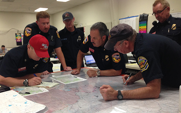
During a large-scale emergency incident, many positions are needed to work a fire. Turner is assigned to an incident management team in San Diego County. He works in the Situation Unit under the Planning Section and is the only Fire GIS Specialist in San Diego County. This kind of management team is different from the teams of firefighters that news reports often mention are going to assist other counties.
Currently, another County worker, Stephen Rea, the assistant director of the County’s Office of Emergency Services, is serving on a San Diego Urban Incident Management Team for the North Star and Tunk Block wildfires, the largest in Washington state history, which have burned more than 370,000 acres as of Tuesday. Rea has been in the city of Omak assisting a liaison officer since Aug. 22.
Northern California’s fire season starts months before ours in San Diego County, said Herman Reddick, program manager for the County Fire Authority. “We step in and help our counterparts to the north, and then if necessary, their firefighters and fire management and support teams reciprocate in the fall months when our fire season usually peaks.”
The deployments are a chance to gain valuable experience as well. “Every firefighter and team that responds gains skills that ultimately benefit the County,” Reddick said.
Apparent to firefighters working the Rocky and Jerusalem Fires was just how big of an effect the drought was having on fire behavior. San Diego’s 2003 and 2007 firestorms were wind-driven, but the Rocky and Jerusalem fires had only a very light wind on them and they were just as explosive. Topography and dead and dry brush and trees fueled Northern California’s recent fires, Turner said.
The fire’s incident command paid for Turner to fly up just hours after getting the call and also covered the cost of his rental car. When he arrived at the base camp that evening, he was immediately put to work. Turner usually worked a 12 to 15 hour shift starting at 2 p.m. In his role, he assisted a lead GIS Specialist in his unit, managing an incident database and creating maps in support of the operation.
“The best part of my job is going out on a fire and being a part of a team solely dedicated to protecting property through mapping,” Turner said. “I feel good about myself knowing I’m helping people. I am passionate about fire and fire service. I love what I do, it’s not a ‘job’ to me.”
Some of the critical items Turner produced included the Incident Action Plan map, an overview of the fire handed out to firefighters and support staff as they show up for the 7 a.m. shift. This map is also produced in poster form and used by incident commanders to demonstrate fire progression.
Some firefighters sent to fires are assigned as Field Observers, who wear special GPS (global positioning system) devices to capture the location of burned fire edges, bulldozer lines, and “hand lines” built by crews using hand tools. As many as 25 of these field observers worked the Rocky Fire. Turner would use data from them to create maps. Active fire lines, meanwhile, are drawn using GPS data captured by devices on aircraft.
Turner also helped create travel maps for out-of-town firefighters to navigate to their assignments, as well as what are called suppression repair maps, which are used by fire crews to return terrain to its previous state after the flames have passed.
Turner said he picked up on some tips and tricks while deployed that he plans to apply to any local incident he works in the future. Initially, Turner serves as the lead Fire Authority staffer creating maps in the Fire Authority GIS Trailer while deployed for local fires. Two Fire Authority GIS firefighter trainees can assist as well. If a fire reaches a level where mutual aid is requested, Turner would relinquish the lead GIS role to a state firefighter, but would stay on to assist.
Turner has been doing GIS work for 20 years, but said he’s s learned a lot from working with CAL FIRE.
On this deployment, “I got to see how a large incident was managed,” Turner said. “When the next big fire happens here, hopefully I’ll be better prepared.”